Location
The Wimmera Region of Victoria lies in the west-central part of the state
covering 36 and 37 degrees south and is bordered to the west by South
Australia, to the north by the Mallee Region, to the south by the Western
District and to the east by the Central Region. The Region is 30 thousand
square kilometres in area, 13 per cent of the Victoria's landmass, with four
per cent of its population. Average rainfall varies across the region, ranging
from more than 600 mm in the south-west to around 350 mm in the north-east,
with most falling in spring. Average temperatures are 13.5°C minimum and
maximum 30°C in summer and 3.7°C minimum and 13.3°C maximum in winter.
The Jochinke farm is located in the centre of the townships of Dimboola, Horsham
and Warracknabeal. Each of these towns are also in different shires
Dimboola - Hindmarsh, Horsham - Horsham Rural City Council and Warracknabeal -
Yarriambiack. The farm is roughly located 30 km out of Horsham on
the Blue Ribbon Road. The area that the farm is located in is called Murra Warra
which is aboriginal for 'Place with no water'.
Dimboola
Dimboola,
the town immortalised in the Australian film of the same name, is the Eastern
Gateway to the Little Desert. The town is set on the Wimmera River under big
river red gums and home to an annual rowing regatta held in November. The lawn
covered banks of the river are a relaxing place to throw in a line, while
platypus and their young are frequently seen at dusk, returning to their burrows
along the river banks.
Dimboola comes from the Ceylonese word 'Dimbula' meaning 'Land of Figs'.
William Lloyd is credited with establishing the town of Dimboola in 1859 by
building a store and hotel. Then known as "Nine Creeks", it was later
changed to Dimboola.
In nearby Antwerp you will find the Ebenezer Mission, founded in 1858 by
Moravian missionaries in an effort to Christianise the local Aboriginal peoples.
Today it stands in ruins. It's pale pink stone buildings are surrounded by
wheatfields and bush. A tiny cemetery contains graves of Mission Koories and
Lutheran priests. An Antwerp Koorie, Bobby Kinnear, who won the rich Stawell
Gift footrace in 1883, is buried here. His grave is marked by a Koorie monument
erected in 1985 by the Goolum Goolum Aboriginal Co-operative to remember local
Koories. The National Trust is preserving the building.
Dimboola is approximately 350kms north-west of Melbourne, Victoria
Pop: 1560
Hindmarsh Shire
Council
Click
Here to View Map
Horsham
Horsham
is situated on the banks of the beautiful Wimmera River, and is the unofficial
capital and commercial centre of the Wimmera. Hosting one of the largest ranges
of Service Industries to be found anywhere in Rural Australia, Horsham is
centrally located to Mt Arapiles - Tooan State Park, Little Desert National
Park, Black Ranges State Park and the Northern Grampians. To the south of the
city, an extensive lakes and waterways system offers great fishing.
The town was named after Horsham in Sussex by James Darlot, commonly regarded as
the founder of the Wimmera. Darlot persuaded Melbourne interests to set up a
store and post office in 1849, from which grew the progressive township.
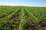
Although originally opened up for grazing purposes, the Wimmera lands became
better known for wheat production, made possible by the introduction of
superphosphate in 1903 and the Federation wheat strain in 1904.
Local foundries sprang up to service the new industry. Land for agriculture was
made available after WW1 and WW2 to returned servicemen with some farming
experience. Horsham was proclaimed a town in 1932, fifty years after it's birth,
and in 1949 it was declared a city.
Horsham is located 301km north-west of Melbourne
Pop: 18,000
Horsham
Rural City Council
Click
Here to view Map
Warracknabeal
Warracknabeal
is a thriving rural commercial township at the centre of the major grain growing
area of the state. Wheat and barley remain the cash crops, but canola, peas,
beans and lupins provide the diversity. The town's Aboriginal name means 'the
place of big red gums shading the watercourse'.
The first to occupy land around the future Warracknabeal township, were the Scott
brothers, who in 1845 moved to a spot on Yarriambiack Creek, which they called
"Warracknabeal", after the Aboriginal word describing the gum trees
shading the watercourse.
There they established their "run" or station. Under the Scott's, the
total area of the Station was reported to be up to 124,000 acres and supported
up to 100,000 sheep.
Many of the early settlers found their properties overrun with wild dogs,
rabbits, kangaroos, emus and wild horses but a recurring shortage of water was
their biggest problem.
Finally the government was able to construct the channel system and provide
permanent water and the district never looked back. Six buildings in the town have been classified by the National Trust. The Post
Office in Scott Street is an attractive example of Tudor style architecture. It
was built in 1909 and remains a unique feature of the shopping centre.
Warracknabeal is 330kms north-west of Melbourne
Pop: 2400
Yarriambiack Shire
Council
Click
Here to View Map